
GPS Coordinate Conversion Calculator

The GPS Coordinate Conversion Calculator is a valuable tool for converting between different geographic coordinate systems. It allows users to easily switch between decimal degrees, degrees minutes seconds, and other formats, making it an essential resource for navigation, mapping, and surveying applications. With its ability to handle various coordinate formats, the calculator simplifies the process of working with GPS data, reducing errors and increasing productivity. By utilizing this calculator, users can efficiently convert coordinates and perform calculations with precision and accuracy, saving time and effort in their work. It is a must-have tool for professionals and enthusiasts alike.
- Understanding the GPS Coordinate Conversion Calculator
- How do I convert GPS coordinates to address?
- How do you convert GPS coordinates from decimals to degrees?
- What is the formula for coordinate conversion?
- How to convert xy coordinates to degrees?
-
Frequently Asked Questions (FAQs)
- What is the GPS Coordinate Conversion Calculator and how does it work?
- What are the different types of coordinate systems supported by the GPS Coordinate Conversion Calculator?
- How accurate is the GPS Coordinate Conversion Calculator and what factors can affect its accuracy?
- What are some common applications of the GPS Coordinate Conversion Calculator in different fields?
Understanding the GPS Coordinate Conversion Calculator
The GPS Coordinate Conversion Calculator is a tool used to convert geographic coordinates between different formats. It is essential for various applications, including navigation, mapping, and surveying. The calculator can convert coordinates between degrees, minutes, and seconds (DMS) format, decimal degrees (DD) format, and Universal Transverse Mercator (UTM) format.
Introduction to Coordinate Systems
A coordinate system is a method of assigning a unique set of numbers to a point on the Earth's surface. The most commonly used coordinate systems are latitude and longitude, which are measured in degrees, minutes, and seconds (DMS) or decimal degrees (DD). The latitude ranges from -90 to 90 degrees, while the longitude ranges from -180 to 180 degrees.
Understanding Degrees, Minutes, and Seconds (DMS) Format
The DMS format is a way of expressing geographic coordinates using degrees, minutes, and seconds. For example, a coordinate in DMS format might be written as 43° 30' 30 N, 122° 30' 30 W. The degrees represent the largest unit of measurement, while the minutes and seconds represent smaller units.
Understanding Decimal Degrees (DD) Format
The DD format is a way of expressing geographic coordinates using decimal degrees. For example, a coordinate in DD format might be written as 43.5050° N, 122.5050° W. The decimal degrees represent the coordinate as a single value, making it easier to perform calculations and conversions.
Understanding Universal Transverse Mercator (UTM) Format
The UTM format is a way of expressing geographic coordinates using a grid-based system. The UTM system divides the Earth into 60 zones, each representing a specific region. The coordinates are expressed in meters east and north of the origin of the zone. For example, a coordinate in UTM format might be written as 10T 0432344 4823432.
Applications of the GPS Coordinate Conversion Calculator
The GPS Coordinate Conversion Calculator has various applications, including:
| Application | Description |
|---|---|
| Navigation | Converting coordinates for navigation systems, such as GPS devices and mapping software |
| Mapping | Converting coordinates for mapping applications, such as creating maps and spatial analysis |
| Surveying | Converting coordinates for surveying applications, such as determining property boundaries and topographic surveys |
| Geocaching | Converting coordinates for geocaching, a recreational activity where players use GPS devices to find hidden containers |
| Research | Converting coordinates for research applications, such as studying climate patterns and geographic information systems (GIS) |
The GPS Coordinate Conversion Calculator is an essential tool for anyone working with geographic coordinates, providing a simple and efficient way to convert between different formats.
How do I convert GPS coordinates to address?
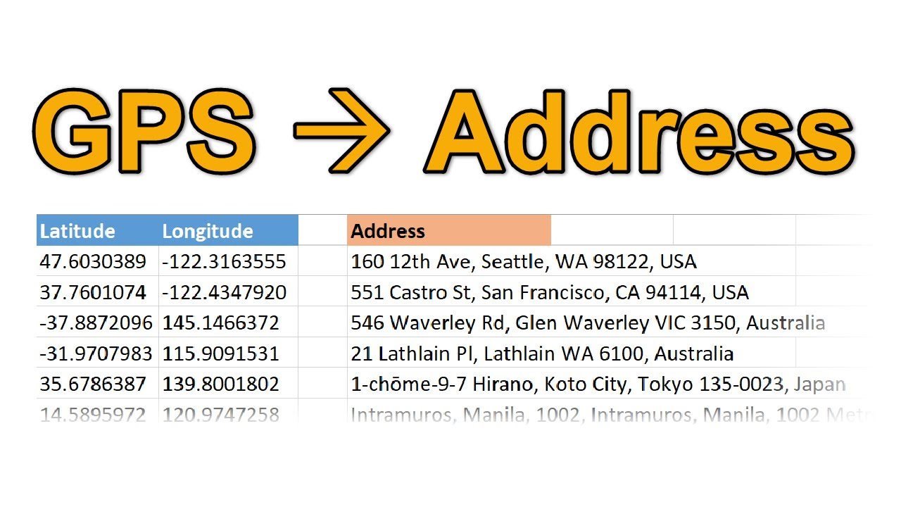
To convert GPS coordinates to an address, you can use a process called reverse geocoding. This involves using a geocoding service or API to take the GPS coordinates and return a human-readable address. There are several ways to do this, including using online tools or programming libraries. One popular option is to use the Google Maps API, which provides a robust and accurate way to convert GPS coordinates to addresses.
Understanding GPS Coordinates
To convert GPS coordinates to an address, you need to understand what GPS coordinates are and how they are formatted. GPS coordinates are typically represented as a pair of latitude and longitude values, which are used to identify a specific location on the Earth's surface. The format for GPS coordinates is usually degrees, minutes, and seconds, although some systems may use decimal degrees instead.
- The latitude value ranges from -90 to 90 degrees, with 0 degrees being the equator.
- The longitude value ranges from -180 to 180 degrees, with 0 degrees being the prime meridian.
- GPS coordinates can be represented in different formats, including DDMMSS (degrees, minutes, and seconds) and DD (decimal degrees).
Using Online Tools for Conversion
There are several online tools available that can convert GPS coordinates to addresses, including GPS coordinate converters and geocoding websites. These tools are often free and easy to use, and can provide a quick and accurate way to convert GPS coordinates to addresses. Some popular options include Google Maps and OpenStreetMap.
- Google Maps provides a reverse geocoding service that can convert GPS coordinates to addresses.
- OpenStreetMap offers a geocoding service that can convert GPS coordinates to addresses.
- Some online tools may have usage limits or require API keys for access.
Programming Libraries for Conversion
For more advanced users, there are several programming libraries available that can convert GPS coordinates to addresses. These libraries are often specific to a particular programming language, such as Python or JavaScript, and may require API keys or subscriptions for access. Some popular options include the Google Maps API and the OpenCage Geocoder.
- The Google Maps API provides a reverse geocoding service that can convert GPS coordinates to addresses.
- The OpenCage Geocoder offers a geocoding service that can convert GPS coordinates to addresses.
- Some programming libraries may have usage limits or require API keys for access.
Challenges and Limitations
Converting GPS coordinates to addresses can be a complex process, and there are several challenges and limitations to consider. One of the main challenges is accuracy, as GPS coordinates may not always correspond to a specific address. Additionally, address formatting can vary depending on the country or region, which can make it difficult to parse and display addresses correctly.
- Address formatting can vary depending on the country or region.
- GPS coordinates may not always correspond to a specific address.
- Geocoding services may have usage limits or require API keys for access.
Best Practices for Conversion
To get the most accurate results when converting GPS coordinates to addresses, it's essential to follow best practices for geocoding and reverse geocoding. This includes using high-quality GPS coordinates, selecting the right geocoding service, and handling errors and exceptions properly. Additionally, it's essential to consider privacy and security concerns when working with GPS coordinates and addresses.
- Use high-quality GPS coordinates to ensure accurate results.
- Select the right geocoding service for your needs, considering factors such as accuracy and usage limits.
- Handle errors and exceptions properly to ensure robust and reliable results.
How do you convert GPS coordinates from decimals to degrees?

To convert GPS coordinates from decimals to degrees, you need to understand the format of the coordinates. Decimal degrees are a way of expressing latitude and longitude as a single decimal number, where the degrees, minutes, and seconds are combined into one value. For example, the latitude 43.7232° N can be converted to degrees, minutes, and seconds by multiplying the decimal part by 60 to get the minutes, and then multiplying the remaining decimal part by 60 to get the seconds.
Understanding Decimal Degrees Format
The decimal degrees format is a simple and efficient way of expressing GPS coordinates. To convert from decimal degrees to degrees, minutes, and seconds, you need to separate the degrees from the decimal part. For example, the longitude 122.0842° W can be converted by taking the whole number part as the degrees, and then multiplying the decimal part by 60 to get the minutes and seconds. The steps to convert are:
- Separate the whole number part from the decimal part
- Multiply the decimal part by 60 to get the minutes
- Multiply the remaining decimal part by 60 to get the seconds
Conversion Steps for Latitude and Longitude
Converting latitude and longitude from decimal degrees to degrees, minutes, and seconds involves the same steps. You start by separating the whole number part from the decimal part, and then apply the conversion factors. The latitude range is from -90 to 90 degrees, and the longitude range is from -180 to 180 degrees. To convert, you need to:
- Check if the coordinate is latitude or longitude
- Apply the conversion factor of 60 to the decimal part
- Round the resulting minutes and seconds to the nearest whole number
Using Online Tools for Conversion
There are many online tools available that can convert GPS coordinates from decimal degrees to degrees, minutes, and seconds. These tools can save time and reduce errors. To use these tools, you simply enter the decimal degree value, select the type of coordinate (latitude or longitude), and then click on the convert button. The tool will display the result in degrees, minutes, and seconds. The advantages of using online tools are:
- Fast conversion with minimal errors
- Easy to use with a simple interface
- Support for multiple formats, including decimal degrees and degrees, minutes, and seconds
Importance of Precision in GPS Coordinates
Precision is crucial when working with GPS coordinates. A small error in the coordinates can result in a large difference in the actual location. When converting from decimal degrees to degrees, minutes, and seconds, it is essential to maintain the precision of the original value. This can be achieved by:
- Using a high-precision conversion method
- Rounding the result to the nearest whole number
- Verifying the result with a map or other GPS device
Common Errors in Converting GPS Coordinates
There are several common errors that can occur when converting GPS coordinates from decimal degrees to degrees, minutes, and seconds. These errors can result from incorrect rounding, inconsistent units, or mismatched coordinate types. To avoid these errors, it is essential to:
- Double-check the conversion method
- Verify the units of the coordinates
- Use a consistent format for the coordinates
What is the formula for coordinate conversion?
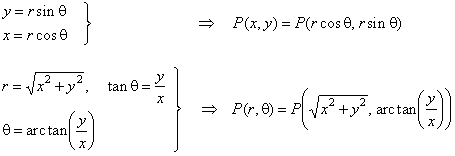
The formula for coordinate conversion depends on the specific type of conversion being performed. In general, it involves using trigonometric functions and geometric transformations to convert between different coordinate systems. The most common types of coordinate conversions are between Cartesian coordinates, spherical coordinates, and cylindrical coordinates.
Conversion from Cartesian to Spherical Coordinates
The conversion from Cartesian coordinates to spherical coordinates involves using the following formulas:
- ρ = √(x² + y² + z²)
- θ = arctan(y/x)
- φ = arccos(z/ρ)
These formulas allow us to convert the x, y, and z coordinates of a point in Cartesian space to the ρ, θ, and φ coordinates of the same point in spherical space.
Conversion from Spherical to Cartesian Coordinates
The conversion from spherical coordinates to Cartesian coordinates involves using the following formulas:
- x = ρsin(φ)cos(θ)
- y = ρsin(φ)sin(θ)
- z = ρcos(φ)
These formulas allow us to convert the ρ, θ, and φ coordinates of a point in spherical space to the x, y, and z coordinates of the same point in Cartesian space.
Conversion from Cartesian to Cylindrical Coordinates
The conversion from Cartesian coordinates to cylindrical coordinates involves using the following formulas:
- r = √(x² + y²)
- θ = arctan(y/x)
These formulas allow us to convert the x, y, and z coordinates of a point in Cartesian space to the r, θ, and z coordinates of the same point in cylindrical space.
Conversion from Cylindrical to Cartesian Coordinates
The conversion from cylindrical coordinates to Cartesian coordinates involves using the following formulas:
- x = rcos(θ)
- y = rsin(θ)
- z = z
These formulas allow us to convert the r, θ, and z coordinates of a point in cylindrical space to the x, y, and z coordinates of the same point in Cartesian space.
Importance of Coordinate Conversion in Real-World Applications
Coordinate conversion is an essential tool in many real-world applications, including navigation, computer graphics, and engineering design. It allows us to transform and analyze data in different coordinate systems, enabling us to solve complex problems and make accurate predictions. By using coordinate conversion formulas and algorithms, we can optimize and improve the performance of various systems and models, leading to increased efficiency and productivity.
How to convert xy coordinates to degrees?

To convert xy coordinates to degrees, you need to understand the relationship between cartesian coordinates and polar coordinates. The conversion involves calculating the angle in degrees from the positive x-axis to the point represented by the xy coordinates. This can be achieved using the arctangent function, which returns the angle in radians, and then converting this angle to degrees. The formula to convert xy coordinates (x, y) to degrees is: degrees = atan2(y, x) 180 / π, where atan2 is a function that returns the arctangent of y/x in radians.
Understanding Cartesian and Polar Coordinates
The conversion from xy coordinates to degrees requires understanding both cartesian coordinates and polar coordinates. Cartesian coordinates represent points in a plane using x and y values, while polar coordinates represent points using a distance from a reference point (radius) and an angle from a reference direction (polar angle). To convert between these two systems, you use trigonometric functions. The key is to calculate the radius and polar angle, where the radius is the distance from the origin to the point, and the polar angle is the angle from the positive x-axis to the line connecting the origin to the point.
- Calculate the radius using the formula: radius = sqrt(x^2 + y^2)
- Calculate the polar angle in radians using the arctangent function: angle radians = atan2(y, x)
- Convert the polar angle from radians to degrees: angle degrees = angle radians 180 / π
Using the Arctangent Function
The arctangent function, or atan, is crucial for converting xy coordinates to degrees. However, the atan function returns the angle in the range -π/2 to π/2, which doesn't account for the quadrant of the point. The atan2 function, on the other hand, returns the angle in the full range -π to π, considering the quadrant of the point. This makes atan2 more suitable for calculating the polar angle. When using atan2(y, x), it correctly determines the angle based on the signs of x and y, ensuring the angle is in the correct quadrant.
- Use atan2(y, x) to calculate the angle in radians, considering the quadrant.
- Apply the formula to convert radians to degrees: degrees = radians 180 / π
- Ensure to handle the case where x or y is zero, as this affects the atan2 result.
Handling Quadrants and Reference Angles
When converting xy coordinates to degrees, understanding the quadrants and how to handle reference angles is essential. The xy plane is divided into four quadrants, each with its own range of angles. The reference angle is the acute angle between the terminal side of an angle and the nearest x-axis. To find the correct angle in degrees, you must consider the quadrant of the point (x, y) and adjust the angle accordingly.
- Determine the quadrant of the point (x, y) based on the signs of x and y.
- Calculate the reference angle using the arctangent function.
- Adjust the angle based on the quadrant to get the correct angle in degrees.
Converting Radians to Degrees
Converting radians to degrees is a straightforward process that involves multiplying the angle in radians by 180/π. This conversion factor comes from the fact that π radians equals 180 degrees. When converting the polar angle from radians to degrees, ensure to maintain the accuracy and consider the quadrant of the point.
- Apply the conversion factor: degrees = radians 180 / π
- Round the result to the desired number of decimal places for accuracy.
- Consider the quadrant and adjust the angle if necessary to ensure it falls within the correct range.
Implementing the Conversion in Programming
Implementing the conversion from xy coordinates to degrees in programming involves using the math library for the arctangent function and the conversion from radians to degrees. Most programming languages provide functions like atan2 and pi, making the implementation straightforward. Ensure to handle edge cases, such as when x or y is zero, and consider the quadrant of the point.
- Import the math library to access trigonometric functions.
- Use atan2(y, x) to calculate the angle in radians.
- Apply the conversion formula to get the angle in degrees: degrees = atan2(y, x) 180 / π
Frequently Asked Questions (FAQs)
What is the GPS Coordinate Conversion Calculator and how does it work?
The GPS Coordinate Conversion Calculator is an online tool designed to convert geographic coordinates between different datum and coordinate systems. It works by taking the input coordinates in one system, applying the necessary transformation algorithms, and producing the equivalent coordinates in the desired output system. This process involves complex mathematical calculations that account for the differences in the reference frames and projections used by each system. The calculator supports a wide range of coordinate formats, including decimal degrees, degrees-minutes-seconds, and UTM coordinates, making it a versatile tool for geospatial data conversion. By using the GPS Coordinate Conversion Calculator, users can easily convert coordinates between different systems, ensuring accuracy and consistency in their geospatial data.
What are the different types of coordinate systems supported by the GPS Coordinate Conversion Calculator?
The GPS Coordinate Conversion Calculator supports a variety of coordinate systems, including geographic coordinate systems like WGS84, NAD27, and NAD83, as well as projected coordinate systems like UTM, State Plane, and Mercator. It also supports datum like WGS84, NAD83, and EGM96, allowing users to convert coordinates between different reference frames. Additionally, the calculator supports custom coordinate systems, enabling users to define their own coordinate system parameters and perform conversions. The GPS Coordinate Conversion Calculator also provides options for units and format, allowing users to specify the input and output coordinate formats, such as decimal degrees, degrees-minutes-seconds, or feet. By supporting multiple coordinate systems and datum, the calculator provides a flexible and powerful tool for geospatial data conversion.
How accurate is the GPS Coordinate Conversion Calculator and what factors can affect its accuracy?
The GPS Coordinate Conversion Calculator is designed to provide highly accurate conversions, with an accuracy of up to 1 cm in some cases. However, the accuracy of the calculator can be affected by several factors, including the quality of the input coordinates, the complexity of the coordinate system conversion, and the parameters used for the conversion. For example, the accuracy of the calculator can be reduced if the input coordinates are inaccurate or incomplete, or if the coordinate system conversion involves a complex transformation. Additionally, the accuracy of the calculator can be affected by the datum and reference frame used, as well as the units and format of the input and output coordinates. To ensure the highest accuracy possible, users should always verify the input coordinates and conversion parameters before performing a conversion, and consult the documentation and help resources provided with the calculator if necessary. By understanding the factors that can affect accuracy, users can use the GPS Coordinate Conversion Calculator with confidence and achieve reliable results.
What are some common applications of the GPS Coordinate Conversion Calculator in different fields?
The GPS Coordinate Conversion Calculator has a wide range of applications in various fields, including surveying, mapping, GIS, engineering, and navigation. In surveying, the calculator is used to convert coordinates between different datum and coordinate systems, ensuring accuracy and consistency in land surveys. In mapping and GIS, the calculator is used to convert coordinates between different projections and reference frames, enabling the creation of accurate and consistent maps and geospatial data. In engineering, the calculator is used to convert coordinates between different systems, facilitating the design and construction of infrastructure projects like roads, bridges, and buildings. In navigation, the calculator is used to convert coordinates between different systems, enabling accurate and reliable navigation and tracking. By providing a powerful and flexible tool for coordinate conversion, the GPS Coordinate Conversion Calculator supports a wide range of applications and industries, from surveying and mapping to engineering and navigation.
Deja una respuesta
Entradas Relacionadas